
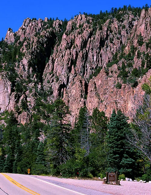
The drive east from Angel Fire offers one of the finest geology lessons in northern New Mexico. Past Eagle Nest, U.S. Highway 64 follows the Cimarron River into Cimarron Canyon, where Cimarron Canyon State Park stretches from Eagle Nest Lake to Ute Park within the 33,116-acre Colin Neblett Wildlife Area. According to the New Mexico Bureau of Geology and Mineral Resources, the canyon exposes nearly two billion years of geologic history, written in cliffs and road cuts that an observer can learn to read.
Click to see more photos of Cimarron Canyon and the Palisades
The oldest chapter is the hardest rock in the canyon. South of the Fowler Pass fault, Proterozoic metamorphic and igneous rocks between about 1.6 and 1.9 billion years old include quartzite, schist, phyllite, and amphibolite that were once sedimentary or igneous rocks heated and squeezed deep within the earth. Granite on the southwest side of the fault has been dated at about 1.4 to 1.5 billion years old. These rocks consist predominantly of quartz, feldspar, and hornblende, with smaller amounts of biotite and epidote, and their banding records pressures no surface process could produce.
Younger rocks tell a story of rivers, deserts, and seas. Red and gray conglomerate, sandstone, shale, and limestone of the Sangre de Cristo Formation were deposited by streams about 320 to 245 million years ago, their red color coming from a thin coating of hematite on individual grains. The Chinle, Entrada, Morrison, and Dakota formations followed, recording rivers, sand dunes with rounded and frosted quartz grains, and finally a shallow Cretaceous sea. Beginning about 75 to 40 million years ago, Laramide mountain building uplifted the Cimarron Range, faulting the canyon country and making room for molten rock to intrude.
That intrusion built the canyon's most famous feature. The Palisades, in the eastern part of the park, are light-gray cliffs formed by a fine-grained Tertiary sill that pushed between older sedimentary and metamorphic layers. More recent dating places the sill at about 25 to 26 million years old. Geologists describe it best as porphyritic dacite, with visible crystals of plagioclase, biotite, hornblende, and quartz set in a fine-grained gray matrix. As the sill cooled it contracted and jointed, and water freezing and thawing in those joints over thousands of years shaped the long columns and towers and left fallen blocks along the river.
For rockhounds, Cimarron Canyon rewards looking more than collecting. Practice identification here: find the porphyritic texture in the Palisades, the frosted quartz grains described in the Entrada Sandstone, and the hematite-red grains of the Sangre de Cristo Formation, and compare them with the gravels the Cimarron River still carries down from the Moreno Valley. Small prospects from the Elizabethtown era survive nearby, but the Bureau notes the canyon and wildlife area are protected from mineral exploration and development, so that history is best appreciated from the road and the trail.
Know before you go
Cimarron Canyon is a place to view geology, not a collecting site, and this article names no collecting location there. Collect only where the land manager confirms collecting is legal. On Bureau of Land Management land, the BLM allows reasonable amounts of rocks, minerals, and gemstones for personal use only, gathered on the surface or with hand tools and no more than minor surface disturbance, and it prohibits collecting in developed recreation sites and on an existing mining claim without the claimholder's permission. Much of the Moreno Valley is private ranch and resort land, so always obtain landowner permission before collecting on private ground, leave cultural items exactly where you find them, check current rules before you go, and pack out everything you pack in.